
|
(Excerpted from a recent email to clients.) Most of you are down here in Florida right now, but many will start heading North soon. As such, I will be ramping up home watch visits as everyone begins to head out. Many of you may also have a few visits remaining on your service plans from last year. Please just text or email me if you you wish to know the status of your plans, or for any other inquiry. For more info on home watch service plan options and pricing, check out these web pages: https://www.hawkhomeplus.com/store/c6/Home_Watch_Inspection_Plans.html or https://www.hawkhomeplus.com/store/c7/Special_Visit_Options.html . As we head into the time where folks are heading back north, I have some information that I’d like to pass along to everyone:
Best Wishes for a Great Spring & Summer, 🖖 -Steve 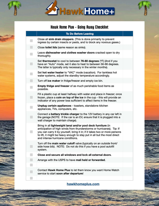
0 Comments
Hello Again Everyone, It’s been an interesting 24 hours and there’s still more to go. In case you missed my broadcast email / blog post from last night, Sunday the 27th, you can find it here in our blog at: https://www.hawkhomeplus.com/blog/tropical-storm-idalia And now it’s time for a further update, straight from the NHC. My summary: Idalia is still a Tropical Storm and is moving slowly near Cuba right now, but expected to speed up when it gets past Cuba tonight and into the open Gulf of Mexico. And its projected track remains to the north and west of Tampa. But Sarasota County remains in a Hurricane Watch, while counties to the north are in Hurricane Warnings. If it maintains this track and does not turn to the east, we here should experience less than hurricane level winds. If it does turn east, well, then all bets are off. Many of you have opted to not put up shutters and I understand and respect that decision. That is the decision Jennifer and I are leaning toward ourselves at the moment. For the five of you who have asked to have their shutters put up, we will work diligently toward completing those tomorrow morning and early afternoon before the heavy rain and tropical winds reach our area. Fingers crossed for us all. Please feel fee to contact me with any questions, etc. Best Wishes, -Steve 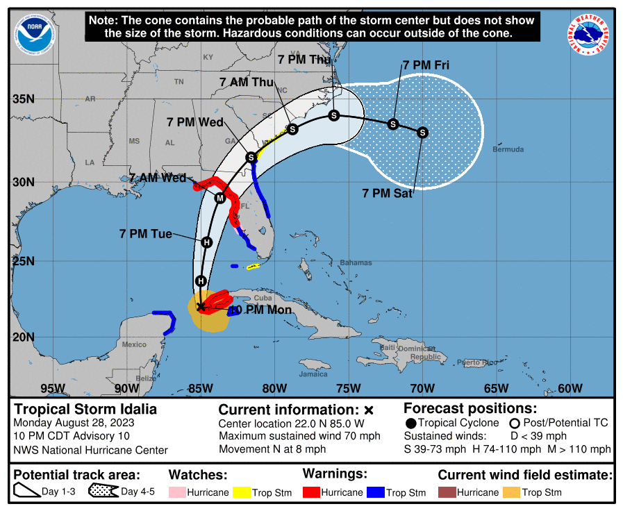 NHC Advisory Text Excerpts:
IDALIA LINGERING NEAR WESTERN CUBA… COULD BECOME A HURRICANE AT ANY TIME AND EXPECTED TO BECOME A MAJOR HURRICANE OVER THE EASTERN GULF OF MEXICO... SUMMARY OF WATCHES AND WARNINGS IN EFFECT: (Most Notable for our Area in Bold) A Storm Surge Warning is in effect for... * Englewood northward to Indian Pass, including Tampa Bay A Hurricane Warning is in effect for... * Cuban province of Pinar del Rio * Middle of Longboat Key northward to Indian Pass, including Tampa Bay A Tropical Storm Warning is in effect for... * Yucatan Peninsula from Tulum to Rio Lagartos, including Cozumel * Isle of Youth Cuba * Dry Tortugas Florida * Chokoloskee northward to the Middle of Longboat Key * West of Indian Pass to Mexico Beach * Sebastian Inlet, Florida to Altamaha Sound, Georgia A Storm Surge Watch is in effect for... * Chokoloskee northward to Englewood, including Charlotte Harbour * Mouth of the St. Mary's River to South Santee River South Carolina A Hurricane Watch is in effect for... * Englewood to the Middle of Longboat Key A Tropical Storm Watch is in effect for... * Lower Florida Keys west of the west end of the Seven Mile Bridge * Altamaha Sound northward to South Santee River South Carolina UPDATE: 5:00pm EDT The projected path of TS Idalia has shifted slightly to the west a bit (see graphic below) and the advisories have been updated (with those pertaining to Sarasota County in Bold): SUMMARY OF WATCHES AND WARNINGS IN EFFECT: A Storm Surge Warning is in effect for... * Englewood northward to Indian Pass, including Tampa Bay A Hurricane Warning is in effect for... * Cuban province of Pinar del Rio * Middle of Longboat Key northward to Indian Pass, including Tampa Bay A Tropical Storm Warning is in effect for... * Yucatan Peninsula from Tulum to Rio Lagartos, including Cozumel * Isle of Youth Cuba * Dry Tortugas Florida * Chokoloskee northward to the Middle of Longboat Key * West of Indian Pass to Mexico Beach A Storm Surge Watch is in effect for... * Chokoloskee northward to Englewood, including Charlotte Harbour * Mouth of the St. Mary's River to South Santee River South Carolina A Hurricane Watch is in effect for... * Englewood to the Middle of Longboat Key A Tropical Storm Watch is in effect for... * Lower Florida Keys west of the west end of the Seven Mile Bridge * Sebastian Inlet Florida northward to South Santee River South Carolina 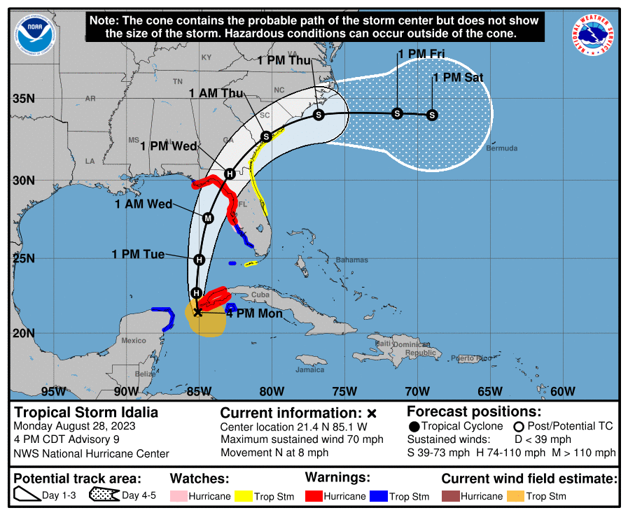 Also, the below is the text of an email we sent to clients last night, Sunday, August 27th, around 11:55pm, ahead of the approach of Tropical Storm Idalia: Hello Everyone, I hope this finds you all well. Let’s get to it... Quick Summary: (1) Tropical Storm Idalia is on its way. (2) As our area is most likely to see between Tropical Storm and Category 1 level winds, we are NOT automatically beginning shutter installations. Decisions on whether to install shutters will need to come from individual homeowners. Please let me know by text or email no later than Monday evening if you want your hurricane shutters installed. Capacity is limited. (3) Also, regular home inspections will be suspended this week in favor of quick, tropical storm focused visits to all homes during the week, hopefully both before and after the storm. We will check lanai conditions, power, water, pools and other items related to storm impacts. (4) We are at capacity for shutter installations if everyone chooses to have them installed, so we may not be able to fit in any additional installations beyond those already enrolled. See Below for more detail... 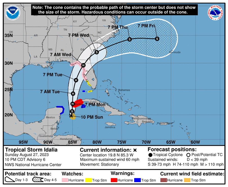 The first Tropical Storm or Hurricane of the 2023 season to come near this area is on its way. Tropical Storm Idalia has now quickly developed in the western Caribbean off the Yucatán rather than starting farther east and trekking across the Atlantic and Caribbean before reaching the Gulf of Mexico. Nevertheless, it is strengthening and moving into the Gulf tonight and is currently forecasted to be headed for the Florida coast anywhere between Ft. Myers and Pensacola on Tuesday or Wednesday. This is a bit less advance notice than we had for Hurricane Ian last September. This storm is currently forecast to develop into a Category 1 or 2 hurricane, depending on where it makes landfall. The farther west and north it goes, the stronger it may become as it spends more time out over water. But, if it instead turns more to the south and east toward us, it may not be much more than a Category 1 if it comes toward Sarasota County. Either way, we are going to see high winds, probably Tropical Storm levels, and possibly even Category 1 Hurricane levels late Tuesday and into Wednesday.
If Idalia continues on the currently forecasted average projected track it could make landfall between Tampa and Panama City, most likely in the Big Bend region of Florida. Again, that is under the current projections. All of the models for the track, as of 11:00pm Sunday, now have it making landfall in that Big Bend region. This can and likely will change somewhat. So, what do we do about this? And do we put up hurricane shutters or not? I know those are the questions on everyone’s minds. The answers are not as clear yet as they were at this point last year with Ian. So, windows and shutters…. Indications are that even the “Scout” standard windows installed in homes in Talon Preserve can withstand the pressure of winds up to at least 120mph. As such, they should be able to withstand the sustained winds of a Category 1 or 2 hurricane. But remember, sustained winds is one thing, gusts are another. A strong gust can reach up to 20% beyond than the sustained winds. However, the ratings for wind strength in hurricanes is for the eye wall at the center. Typical winds lessen in strength further out from the eye. However, the greatest danger to windows is not necessarily the winds themselves but rather the impacts of debris. And debris is very hard to predict. All that being said, while I made the decision last year to install shutters on all homes on our list, that was because Hurricane Ian, as a Category 4 to 5 storm, presented a much stronger and more likely danger. For a Category 1 or 2 storm, I will leave the decision of whether to install shutters up to each homeowner. Please let me know by text or email no later than Monday evening if you want your hurricane shutters installed. If you have any questions, comments or concerns, please feel free to contact us through our About Contact Form (or our direct client information if you are a client, neighbor or friend). We want to make sure everyone’s home is well taken care of, but time and resources are limited. Also, if you are in the neighborhood and would like to help out with installing any shutters for other neighbors (for compensation, of course), please feel free to contact me about that as well. Sincerely, - Steve Hawk —————— For the most up-to-date information about ongoing tropical storms, be sure to go the National Hurricane Center's website: https://www.nhc.noaa.gov/ For reference, Atlantic and Gulf hurricanes are classified on the Saffir-Simpson Hurricane Wind Scale(SSHWS). Those classes are as follows:
For further reference, Hurricane Ian peaked as a Category 5 hurricane with sustained winds of 160 mph early on September 28, while progressing towards the west coast of Florida, and made landfall just below peak intensity in Southwest Florida on Cayo Costa Island, directly south of Boca Grande (Gasparilla Island) and just north of North Captiva Island near Cape Coral and Fort Meyers. Ian made first landfall at about 3:05pm EDT with sustained winds of 150 mph, becoming the first Category 4 hurricane to impact Southwest Florida since Charley in 2004, which made landfall at the same location. Ian then made a second landfall just south of Punta Gorda near Pirate Harbor at 4:35pm EDT with 145 mph winds. Concierge services are here... officially. We've already been providing these types of services since the beginning of our operation, but now we are clarifying and simplifying how we handle and bill them out for you.
There are several definitions of the word concierge, but they all generally involve an employee or contractor providing general assistance and errand services to a guest or client. At Hawk Home Plus we aim to provide our out-of-town part-time resident clients with a range of additional services beyond just the general frequent check-in home watch inspections of their homes. The types of services we can provide under the heading of concierge services may include: - picking up mail; - picking up and placing inside a delivered package; - meeting delivery persons or contractors at the home to permit access and monitor activities; - taking out and putting in trash/recycling bins before and after trash day morning; - turning on water, hot water, and AC to desired levels prior to arrival of the owner or a guest at the home; providing rides to and from local airports; and any other general assistive services for a vacant or part-time home. With all of these services, we ask our clients to please contact us (at the contact information we have provided you as clients) in advance to arrange for the type of service and the times and dates. To account for our time, we will generally bill you on an hourly rate basis. Reflecting the same rate offered for our "Good Neighbor Quick Visit", we have set the hourly rate for all services outside our standard home inspection plans at $60/hour. June 12, 2023
We are rolling out our Hurricane Preparation Options now! And it all starts with the new Hurricane Preparation Enrollment service. This new option, available for purchase online will provide two (2) things:
This Hurricane Preparation Enrollment option will be available starting today at a discounted price of US$50. As August and September are typically the peak months for Gulf hurricanes, on August 1st, the cost to enroll will go up to its full US$75 price. So be sure to sign up earlier rather than later! Learn more about this enrollment option as well as tentative Hurricane Shutter Installation pricing on our Hurricane Preparation page. Leaving for Summer - Tips and Suggestions
Here is a list of a few general tips for preparing your home for when you are away (in all seasons, not just hurricane season):
And if you have any comments, questions or concerns about these or any other precautions… Contact Us! |
Hawk
|
 RSS Feed